Boomerang
-
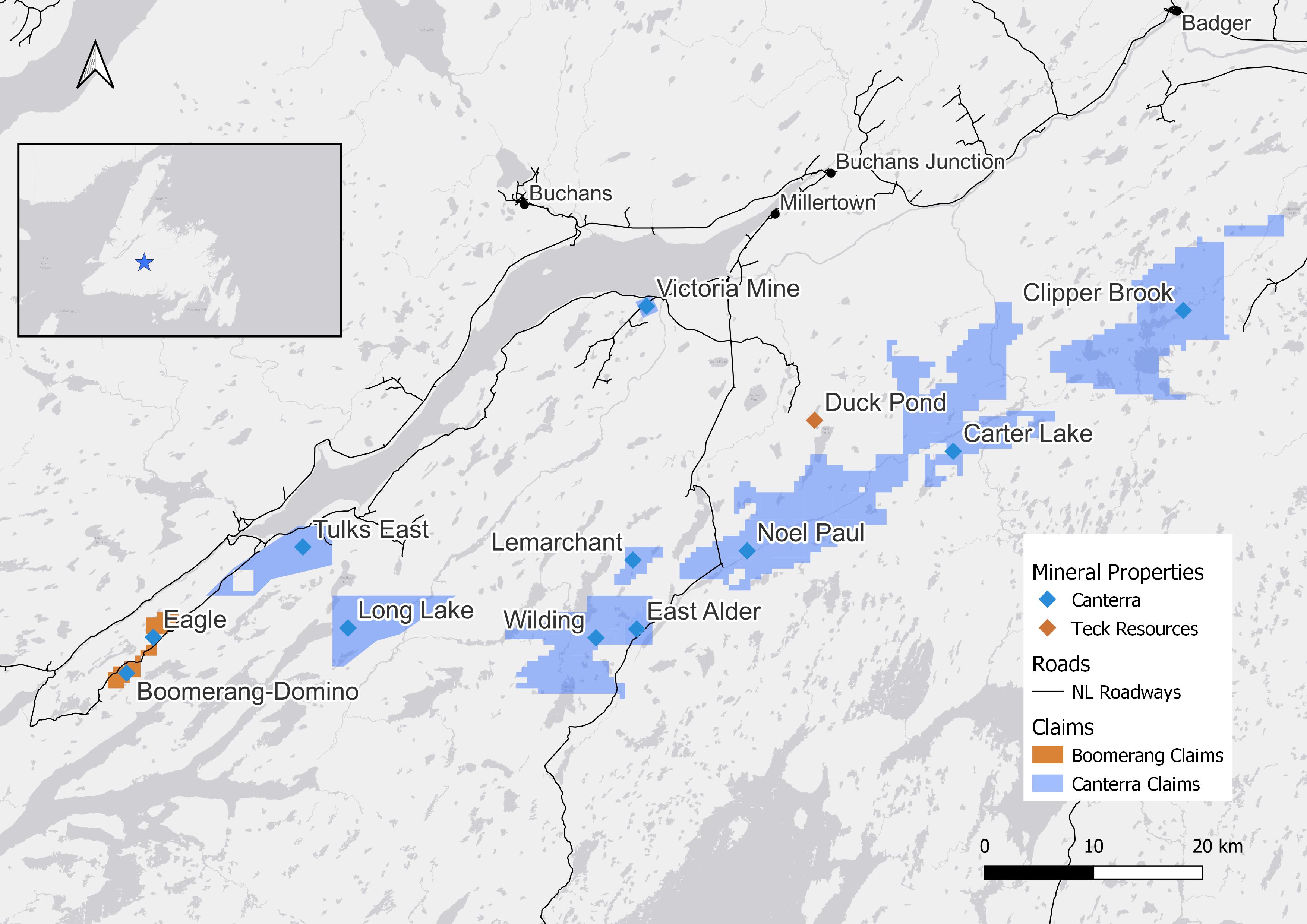
The 100%-owned Boomerang Property is located approximately 50 kilometres southwest of Buchans along well maintained gravel roads. The property is host to the significant Cu-Pb-Zn-Ag-Au VMS Boomerang-Domino deposit. Numerous other VMS and Gold prospects and occurences remain underexplored on the property. The property is located approximately 65 kilometres southwest of Teck Resources closed (2015) Duck Pond Cu-Zn mine, and 15 kilometres northwest of Marathon Golds construction phase Valentine Lake Project.
Key Highlights:
- Excellent road access and nearby infrastructure (power, workforce, services)
- Significant Cu-Pb-Zn-Ag-Au VMS deposits including the Boomerang deposit, Domino deposit and Hurricane Prospect
- A total of 191 drill holes and over 70,000 m have been completed at the Boomerang-Domino deposit
- Greenfields and Brownfields discovery potential along highly prospective volcanic belt for both base metal and gold deposits
2007 NI 43-101 compliant evaluation of the Boomerang and Domino deposits resulted in the following initial resource estimtate:
Deposit Category Tonnes Zinc (%) Lead (%) Copper (%) Silver (g/t) Gold (g/t) Cut-off Boomerang Indicated 1,364,600 7.07 3.00 0.51 110.2 1.66 1% Zn Inferred 278,100 6.72 2.88 0.44 96.5 1.29 1% Zn Domino Inferred 411,200 6.30 2.80 0.40 94.0 0.60 1% Zn -
The Boomerang property is located apporixmately 70km to the southwest of Buchans or Millertown in Central Newfoundland. Easily accessible by a network of gravel resource roads.
Local infrastructure is excellent with 18MW Star Lake hydroelectric generating station 20km from the Boomerang deposit and trans-island 230-kV power lines running just adjacent to the property. Canterra operated Pat's Pond field camp is located 2.5km from the main deposits with accomadation for 45 people, kitchen, septic and water facilities. Services and personnel can be located in close proximity to the projects throughout Central Newfoundland in Buchans and Grand Falls-Windsor (2 hour drive) or Western Newfoundland in Stephenville and Corner Brook (2 hour drive).
-
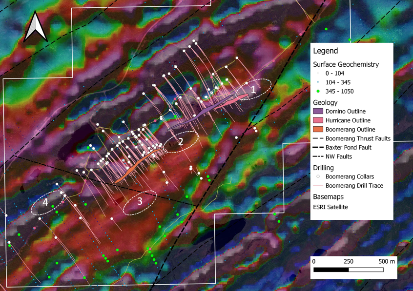
The Boomerang property is underlain by the highly prospective Tulks Hill Volcanic Assemblage of the Victoria Lake Supergroup. The Tulks Hill Volcanic Assemblage is an extensive northeast trending belt of felsic and mafic pyroclastic rocks and flows, mafic dykes, intercalated sediments, and sub-volcanic intrusions metamorphosed to greenschist facies. Prospective felsic volcanic rocks extend the 60 kilometre length of the volcanic belt and contain extensive zones of volcanogenic alteration associated with massive sulphide formation. The southeast margin is defined by the magnetic anomaly fault zone in contact with the Long Lake Belt volcanic rocks and the northwest side is overlain by sedimentary and volcaniclastic rocks of the Harbour Round belt.
The rocks within the Tulks South Property area have undergone moderate to strong penetrative deformation and primary textures are frequently obscured or entirely obliterated by a well developed, bedding parallel foliation. The strata are generally steeply dipping and northwest-facing. Small scale isoclinal folds with sub-vertical plunges are common but evidence of large scale folding is sparse. Two phases of foliation are mapped; many of the sulphide zones within the belt plunge to the northeast so structural modification of the massive sulphides have occurred. Later shear zones also transect the property trending near the orientation of the dominant foliation. These shear zones enclose large areas of argillic alteration (sericite and pyrite +/- silica, carbonate, etc.) which are locally gold-bearing. Younger, high-angle faulting is interpreted to offset structural-stratigraphic units by up to 500 metres in places.
Exploration Targets:
- Along strike extensions of Hurricane and Domino deposits to the NE. Roughly 550m of unexplored strike to Baxter Pond Fault
- Down dip extension of Boomerang and potential SW extension of Domino
- Portential mineralization offset by WNW and NW treding faults along modelled sinstral fault structures
- SW strike extent of Boomerang deposit along anomalous high Zn area and geophysical target
-
Deposit Category Tonnes Zinc (%) Lead (%) Copper (%) Silver (g/t) Gold (g/t) Cut-off Boomerang Indicated 1,364,600 7.07 3.00 0.51 110.2 1.66 1% Zn Inferred 278,100 6.72 2.88 0.44 96.5 1.29 1% Zn Domino Inferred 411,200 6.30 2.80 0.40 94.0 0.60 1% Zn 1. Resource tonnages have been rounded to the nearest 10,000. Totals may vary due to rounding.
2. A full block grade cut‐off of 1.0 % Zn Eq. was used to estimate Mineral Resources
3. Boomerang Assay composites (1 metre) were capped at 29.8% Zn, 11.8% Pb, 8.85 g/t Au, 422 g/t Ag, and 1.77% Cu; Domino Assay composites were capped at 24% Zn, 10.0% Pb, 1.692 g/t Au, 335 g/t Ag, and none for Cu
4. Results of an interpolated Ordinary Kriging bulk density model (g/cm3) have been applied
5. Mineral Resources are considered to reflect reasonable prospects for economic extraction in the foreseeable future using conventional underground mining methods
6. Mineral Resources do not have demonstrated economic viability.
7. This estimate of Mineral Resources may be materially affected by environmental, permitting, legal title, taxation, sociopolitical, marketing, or other relevant issues. -
Deposit BHID From (m) To (m) Length (m) Au (g/t) Cu (%) Pb (%) Zn (%) Ag (g/t) Boomerang GA07-241 233.31 238.31 5.00 0.5 0.7 3.7 10.2 82 GA07-245 282.83 308.94 26.11 2.5 0.5 3.0 8.0 116.0 GA07-228 336.70 350.73 14.03 0.6 0.5 3.4 11.3 91.0 GA07-222 317.87 339.55 21.68 0.8 0.5 2.6 9.2 78.0 Domino GA06-100 514.02 517.55 3.53 1.3 1.0 8.7 23.8 267.0 GA06-197 566.25 573.05 6.80 1.3 0.4 5.1 10.9 144.0 GA06-107 524.70 525.86 1.16 1.1 1.1 7.9 17.4 322.0 Hurricane GA14-278 301.95 303.65 1.70 0.7 0.7 8.2 13.2 135.8